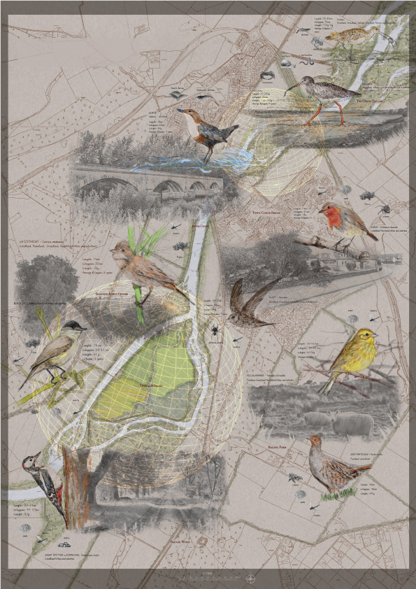


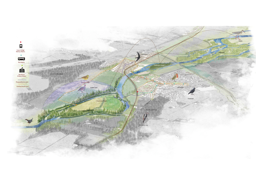
Background: Cromarty Firth presents complex land use, with the intersection of sea and freshwater, highlands, and vast plains. Springwater flows down from a high place to the estuary; freshwater seeps in the firth and flows into the North Sea. There are settlements, farmland, and large forests on both sides of the firth. These places are all inhabited by interacting biological communities. Besides humans, some of the most obvious members of this community, other species are experiencing and forming the landscape here. Such as butterflies, voles, Roe deer, Hares. In particular, the Cromarty Firth area and sea areas are also classified under the EU Birds Directive as Special Protection Area in the UK. Wild birds in Cromarty Firth are mainly distributed in farmland, intertidal zone, coastal, woodland and estuary areas, and even community gardens are often foraging areas for various small birds.
Concept: Humans often have certain limitations in exploring the landscape. This is because we are still unable to think and observe the surrounding habitat from the perspective of other life. In order to make a new attempt in landscape research, this project will focus on exploring a new design theory to understand the relationship between humans and non-humans in the landscape. I will choose birds as the representatives of non-humans to explore in detail the way of bird habitat selection and how communities can use their autonomy to reduce the damage to the bird’s habitat.
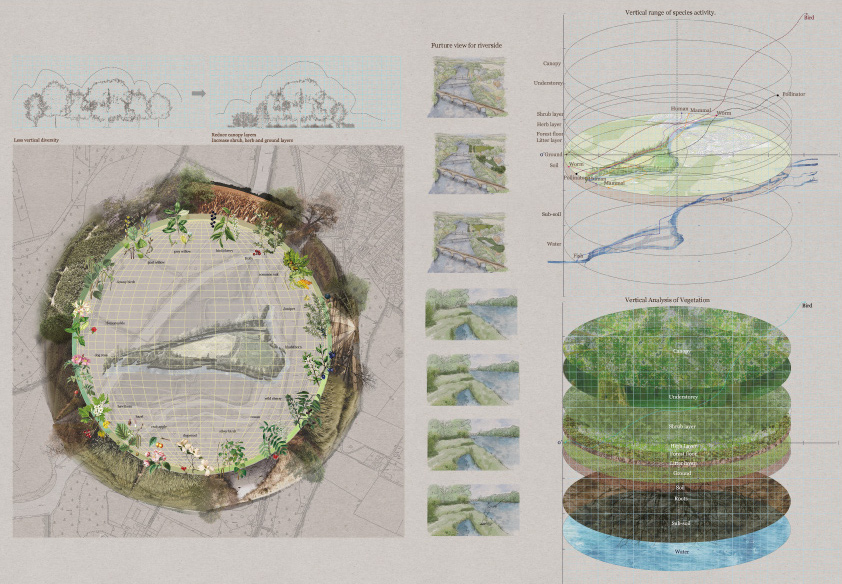
The main purpose of symbiotic islands is to use freshwater islands as the starting point and center of habitat restoration to expand the positive ecological structure to the surrounding environment that lacks diversity. The design of a symbiosis island between humans and non-humans needs to start from two perspectives. First, consider how to encourage people to be aware of the autonomy of the landscape. In order to participate in the landscape design process. Secondly, it is to pull away from the human perspective and try to learn from the non-human interaction mode with the landscape the requirements of non-human habitat selection. Thus, the design of plants and land cover can allow non-humans to find a private and quiet habitat on the island.
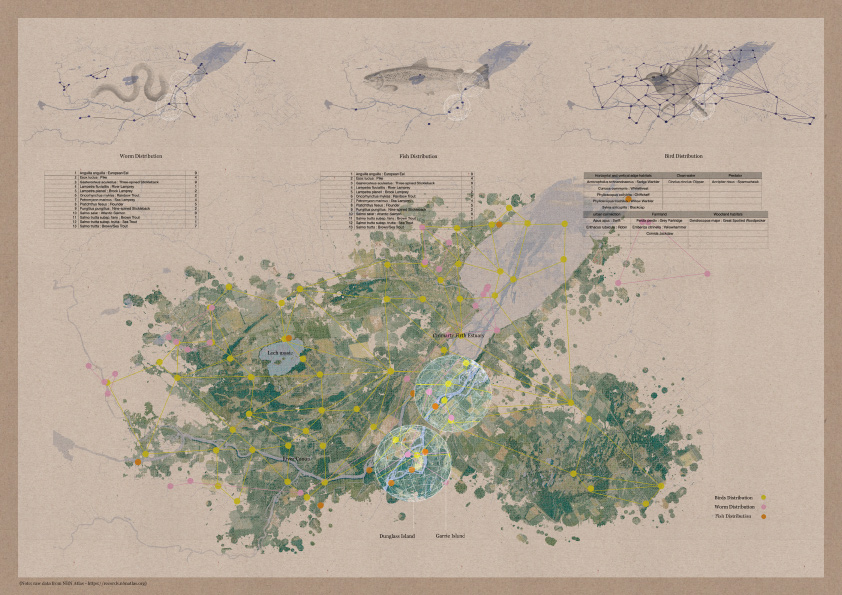
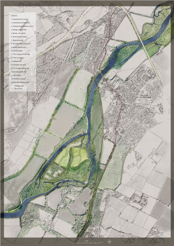
After reviewing the research of last semester, I focused on the Conon River where the fresh water and saltwater meet. There are two freshwater islands near the estuary of the Cromarty Firth, Garrie Island, and Dunglass Island. Neither of these freshwater islands is inhabited by humans. Neither of these freshwater islands is inhabited by humans. The difference is that Garrie Island is not connected to the land on both sides of the river. It is an island that is not used by humans. However, Dunglass Island is mainly covered by farmland and mainly grows winter wheat and spring barley. Through the analysis of the data, I found that the ecological diversity of Dunglass Island is lower than that of Garrie Island and urban areas. This is because intensive agricultural activities pose serious threats to soil, water sources, vegetation, and wildlife. After Brexit, farmers can escape from the common agriculture diversity. Not only focus on food output but consider how to deliver public good and maintain the diversity of non-human habitats.
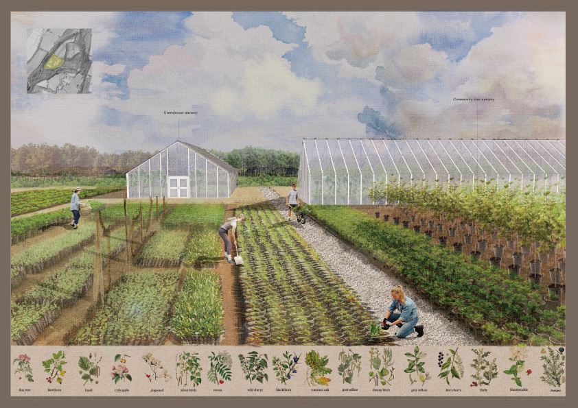
In addition, Dunglass Island is located between two important towns, Conon Bridge and Maryburgh. After searching some pictures on social media, I found that Dunglass island is a hiking place that often arouses the interest of tourists and residents. However, it is not difficult to find that it lacks connectivity with the surrounding landscape. Therefore, I think it is necessary to design the land cover conversion of the island. The south of the island is mostly surrounded by wet woodland, which is an important habitat for birds and other wild animals. The positive habitat here should be expanded. While ensuring that this island becomes a symbiotic island between humans and non-humans, it is also important to maintain the original productivity of the landscape. Therefore, I used about a quarter of the area to design the community nursery area. It can encourage people to interact with the landscape and provide a sustainable supply of plants for surrounding towns and farmland edges. From the analysis of the dynamic changes of the water catchment, it can be seen that the shape of Dunglass has been changing with the scouring of the river. The erosion effect of river water on the land is intensified with changes. Hence, a large area of the rain garden and buffer zone is set up on both sides of the stream in the middle of the island. A new bridge was designed on the east side of the island where it connects with the riverbank. This facilitates the residents of Conon Bridge to visit the island. As it is close to the railway station and schools, this provides potential opportunities for the development of education and tourism in the landscape. In the use of materials in the detailed design, considering the sensitivity of birds to transparent materials, I chose two bird-friendly materials to prevent birds window collision.
The design of the symbiosis island of humans and non-humans is a comprehensive exploration project of the landscape. It not only considers the needs for ecological balance in the landscape, but also combines important factors such as community culture, transportation, and political background. The design of this island reflects my overall and specific understanding of the Cromarty Firth complex landscape system in many aspects。
Looking for potential research areas: After reviewing the results of the previous semester, it is concluded that the landscape of Cromarty Firth is often shaped by the diversion and erosion of the river and the change of tides. Therefore, the first phase of the study focused on the confluence area of fresh water and saltwater in the Cromarty firth area. It could be seen from the map that the type of land cover in this area is very complicated. This is an area where birds gather and are close to three historical towns.

Dunglass island, the largest freshwater island in the Cromarty firth area, is part of the rainwater and groundwater filtration system. It has an important ecological impact on the river water before it enters the sea. In addition, Dunglass island is surrounded by different land cover types, such as agricultural land, freshwater, forestry land, and towns. The ecosystem between these sites lacks coherence.

「Starting from Dunglass Island, the positive habitat area could be extended to towns and estuary areas. Focus on the transitional areas of different land cover types and enhance the continuity of the surrounding landscape. Aim to create foraging and resting places for birds.」
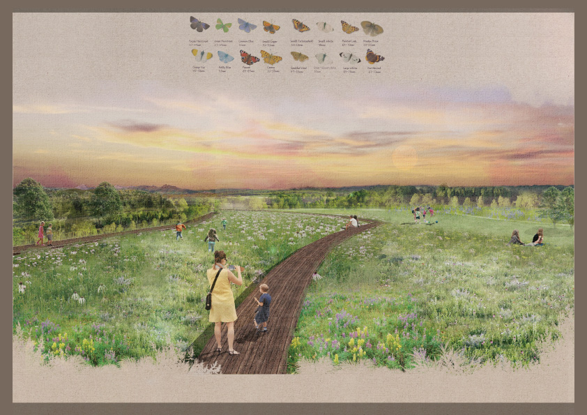
Transform the original agricultural land into open landscape areas with different functions. Including woodland extension, rain garden, community tree nursery, grassland, meadows, etc. Those positive habitats were created by Dunglasss Island as a starting point to create a new freshwater island park and spread to Garrie Island, Conon Riverside, and the surrounding farmland edge. Restore the ecological diversity while maintaining the original productivity of the landscape. There are walking trails and cycling roads in Island Park which encourage communities to participate in the shaping of the landscape and provide them with a place for outdoor activities and communication. In addition, the original wet woodland has been preserved to provide a private and quiet habitat for non-humans and the log jam project has been set up to help fish in the spawning crisis
Loss of mixed farming causing a loss of habitat diversity, leading to less diversity of plants and animals and fewer opportunities for birds to forage in different habitats throughout the year. Increased use and efficacy of pesticides leading to the loss of insect food and weed seeds. Increased field sizes have caused the loss of nesting habitat for some species. Moreover, the loss of insect-rich foraging habitat and weedy field margins. Field drainage removed wetland habitats and damp areas with more soil invertebrates which provided food for birds.
Shifting agricultural land to planting land slows the output cycle of the landscape. Plants in the nursery can be transplanted to farmland edges and towns when they are mature, creating a sustainable and productive habitat